Hatfield Consultants

  • About
    • At A Glance
    • Our Leaders
    • Our History
    • Corporate Social Responsibility
    • Quality Management
    • Health & Safety
    • Environmental Policy
    • Indigenous Relations
    • Regions
      • Canada
      • Indonesia
      • Africa
  • Services
    • Water
      • Fish & Fish Habitat
      • Effects Monitoring & Ecotoxicology
      • Hydrology
      • Hydrogeology
      • Marine Ecology
      • Marine & Coastal Infrastructure
      • Regulatory Permitting
    • Land
      • Infrastructure Development
      • Vegetation & Wetlands
      • Forestry
      • Wildlife
      • Regulatory Permitting
    • People
      • Social Science
      • Engagement & Consultation
      • Knowledge Management
      • Human Centered Design
    • Technology
      • GIS & Mapping
      • Remote Sensing
      • Data & Information Management
      • Data Analytics
  • Sectors
    • Marine
    • Forestry
    • Infrastructure
    • International Development
    • Mining & Exploration
    • Oil & Gas
    • Pulp & Paper
    • Clean Energy
  • Projects
  • News
  • Careers
    • Why Work at Hatfield?
    • Current Opportunities
  • Contact

Wetland Classification for a Boreal Wetland Complex

You are here: Home / Projects / Wetland Classification for a Boreal Wetland Complex

Wetland Classification for a Boreal Wetland Complex

Client

Not disclosed

Location

Northern Alberta

Project Duration

June 2018 – December 2018

Background

Many natural resources development companies require wetland and upland land cover classification information to characterize baseline conditions as the basis for long-term monitoring for potential impacts to the wetlands and surrounding watershed land cover during the development, operation, and closure of projects.

Services Provided

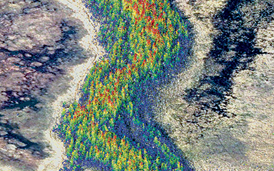
Hatfield developed a wetland and upland vegetation classification approach using multiple remote sensing datasets and advanced machine learning analysis and object-based integration methods. The objective of this project was to produce a comprehensive land cover classification following the Alberta Wetland Classification System (AWCS). The approach included object-based image analysis and machine learning methods, which enabled the integration of high-resolution Worldview-3 imagery, Sentinel-2, and full point cloud LiDAR. To address the requirements of the AWCS to identify coniferous, deciduous and mixed-species composition forest stands, we used the Lidar point cloud data to delineate individual tree crowns, which were then categorized as either coniferous or deciduous using the high-resolution multi-spectral satellite data. The final classification dataset was presented at the stand level and was consistent with the AWCS, and included class (bog, fen, swamp, marsh, and open water) and form (graminoid, shrub, treed). A full accuracy assessment and uncertainty analysis was completed to provide quality assurance to the final products.

Wetland Classification for a Boreal Wetland Complex

August 6, 2020 by

Find out more about our services from our team of technical experts

Connect With Us
  • Home
  • About
  • Projects
  • News
  • Careers
  • Contact
  • Agent Orange

Sectors

  • Marine
  • Forestry
  • Infrastructure
  • International Development
  • Mining & Exploration
  • Oil & Gas
  • Pulp & Paper
  • Clean Energy

Services

  • WATER
  • Fish & Fish Habitat
  • Effects Monitoring & Ecotoxicology
  • Hydrology
  • Hydrogeology
  • Marine Ecology
  • Marine & Coastal Infrastructure
  • Regulatory Permitting
  • LAND
  • Infrastructure Development
  • Vegetation & Wetlands
  • Forestry
  • Wildlife
  • Regulatory Permitting
  • PEOPLE
  • Social Science
  • Engagement & Consultation
  • Knowledge Management
  • Human Centered Design
  • TECHNOLOGY
  • GIS & Mapping
  • Remote Sensing
  • Data & Information Management
  • Data Analytics
Copyright © 2021 Hatfield Consultants
  • Terms & Conditions
  • Privacy Policy
  • About
    ▼
    • At A Glance
    • Our Leaders
    • Our History
    • Corporate Social Responsibility
    • Quality Management
    • Health & Safety
    • Environmental Policy
    • Indigenous Relations
    • Regions
      ▼
      • Canada
      • Indonesia
      • Africa
  • Services
    ▼
    • Water
      ▼
      • Fish & Fish Habitat
      • Effects Monitoring & Ecotoxicology
      • Hydrology
      • Hydrogeology
      • Marine Ecology
      • Marine & Coastal Infrastructure
      • Regulatory Permitting
    • Land
      ▼
      • Infrastructure Development
      • Vegetation & Wetlands
      • Forestry
      • Wildlife
      • Regulatory Permitting
    • People
      ▼
      • Social Science
      • Engagement & Consultation
      • Knowledge Management
      • Human Centered Design
    • Technology
      ▼
      • GIS & Mapping
      • Remote Sensing
      • Data & Information Management
      • Data Analytics
  • Sectors
    ▼
    • Marine
    • Forestry
    • Infrastructure
    • International Development
    • Mining & Exploration
    • Oil & Gas
    • Pulp & Paper
    • Clean Energy
  • Projects
  • News
  • Careers
    ▼
    • Why Work at Hatfield?
    • Current Opportunities
  • Contact