Hatfield Consultants

  • About
    • At A Glance
    • Our Leaders
    • Our History
    • Corporate Social Responsibility
    • Quality Management
    • Health & Safety
    • Environmental Policy
    • Indigenous Relations
    • Regions
      • Canada
      • Indonesia
      • Africa
  • Services
    • Water
      • Fish & Fish Habitat
      • Effects Monitoring & Ecotoxicology
      • Hydrology
      • Hydrogeology
      • Marine Ecology
      • Marine & Coastal Infrastructure
      • Regulatory Permitting
    • Land
      • Infrastructure Development
      • Vegetation & Wetlands
      • Forestry
      • Wildlife
      • Regulatory Permitting
    • People
      • Social Science
      • Engagement & Consultation
      • Knowledge Management
      • Human Centered Design
    • Technology
      • GIS & Mapping
      • Remote Sensing
      • Data & Information Management
      • Data Analytics
  • Sectors
    • Marine
    • Forestry
    • Infrastructure
    • International Development
    • Mining & Exploration
    • Oil & Gas
    • Pulp & Paper
    • Clean Energy
  • Projects
  • News
  • Careers
    • Why Work at Hatfield?
    • Current Opportunities
  • Contact

Watershed Characterization Data and Approaches for BC

You are here: Home / Projects / Watershed Characterization Data and Approaches for BC

Watershed Characterization Data and Approaches for BC

Client

Province of British Columbia, Ministry of Agriculture, Food and Fisheries (AFF) and Ministry of Land and Water Resource Stewardship (LWRS)

Location

British Columbia

Project Duration

2021 – 2022

Background

Watershed characterizations serve as a starting point for understanding the available data, values, and challenges present within a given watershed.  In 2021, Hatfield was tasked with providing an update of the 2013 version of the B.C. Desktop Watershed Characterization guidelines. Hatfield’s 2022 document update involved compiling and reviewing a suite of data sources for watersheds which can aid in developing monitoring plans, research projects, setting water quality objectives, and/or to inform planning and permitting of industrial or other end uses and associated effects assessments.

Hatfield’s 2022 update provides an expanded list of data sources, information, and methods available in BC to guide watershed characterizations. Relative to the 2013 guidelines, the scope of this update also includes the identification of data sources to determine additional watershed characteristics, namely climate change, aquatic ecology, groundwater, geology/geomorphology, and socio-cultural values.

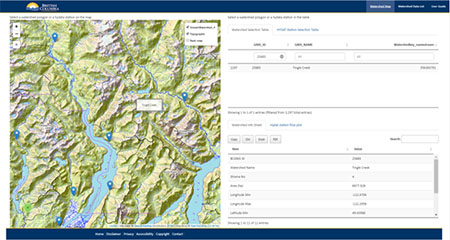
Given the breadth and number of data sources available. Hatfield was also tasked with developing an associated R-Shiny web app (see image, top right) intended to support watershed characterization. This app demonstrates how vector, raster, and tabular data can interact to support a watershed characterization. This app provides a web version of the updated report, allowing users to find resources about water quality, surface water, ground water, climate change, hydroclimate, watershed land use, watershed disturbance, geology geomorphology, ecological values, and cultural values. It also provides an interactive way to select watershed and hydrometric stations from both a map and a list table, then generates a on-the-fly data processing report and data visualization result.

Services Provided

The core responsibilities of Hatfield’s environmental team included:

  1. Engagement with Provincial regulators and scientists to confirm key watershed attributes and potential characterization objectives
  2. Identification of updated data sources and information to support BC watershed characterization
  3. Revision of the existing watershed characterization report
  4. Development of a prototype web application using R Shiny for watershed and hydrometric data visualization

Watershed Characterization Data and Approaches for BC

September 8, 2022 by

Find out more about our services from our team of technical experts

Connect With Us
  • Home
  • About
  • Projects
  • News
  • Careers
  • Contact
  • Agent Orange

Sectors

  • Marine
  • Forestry
  • Infrastructure
  • International Development
  • Mining & Exploration
  • Oil & Gas
  • Pulp & Paper
  • Clean Energy

Services

  • WATER
  • Fish & Fish Habitat
  • Effects Monitoring & Ecotoxicology
  • Hydrology
  • Hydrogeology
  • Marine Ecology
  • Marine & Coastal Infrastructure
  • Regulatory Permitting
  • LAND
  • Infrastructure Development
  • Vegetation & Wetlands
  • Forestry
  • Wildlife
  • Regulatory Permitting
  • PEOPLE
  • Social Science
  • Engagement & Consultation
  • Knowledge Management
  • Human Centered Design
  • TECHNOLOGY
  • GIS & Mapping
  • Remote Sensing
  • Data & Information Management
  • Data Analytics
Copyright © 2021 Hatfield Consultants
  • Terms & Conditions
  • Privacy Policy
  • About
    ▼
    • At A Glance
    • Our Leaders
    • Our History
    • Corporate Social Responsibility
    • Quality Management
    • Health & Safety
    • Environmental Policy
    • Indigenous Relations
    • Regions
      ▼
      • Canada
      • Indonesia
      • Africa
  • Services
    ▼
    • Water
      ▼
      • Fish & Fish Habitat
      • Effects Monitoring & Ecotoxicology
      • Hydrology
      • Hydrogeology
      • Marine Ecology
      • Marine & Coastal Infrastructure
      • Regulatory Permitting
    • Land
      ▼
      • Infrastructure Development
      • Vegetation & Wetlands
      • Forestry
      • Wildlife
      • Regulatory Permitting
    • People
      ▼
      • Social Science
      • Engagement & Consultation
      • Knowledge Management
      • Human Centered Design
    • Technology
      ▼
      • GIS & Mapping
      • Remote Sensing
      • Data & Information Management
      • Data Analytics
  • Sectors
    ▼
    • Marine
    • Forestry
    • Infrastructure
    • International Development
    • Mining & Exploration
    • Oil & Gas
    • Pulp & Paper
    • Clean Energy
  • Projects
  • News
  • Careers
    ▼
    • Why Work at Hatfield?
    • Current Opportunities
  • Contact