Hatfield Consultants

  • About
    • At A Glance
    • Our Leaders
    • Our History
    • Corporate Social Responsibility
    • Quality Management
    • Health & Safety
    • Environmental Policy
    • Indigenous Relations
    • Regions
      • Canada
      • Indonesia
      • Africa
  • Services
    • Water
      • Fish & Fish Habitat
      • Effects Monitoring & Ecotoxicology
      • Hydrology
      • Hydrogeology
      • Marine Ecology
      • Marine & Coastal Infrastructure
      • Regulatory Permitting
    • Land
      • Infrastructure Development
      • Vegetation & Wetlands
      • Forestry
      • Wildlife
      • Regulatory Permitting
    • People
      • Social Science
      • Engagement & Consultation
      • Knowledge Management
      • Human Centered Design
    • Technology
      • GIS & Mapping
      • Remote Sensing
      • Data & Information Management
      • Data Analytics
  • Sectors
    • Marine
    • Forestry
    • Infrastructure
    • International Development
    • Mining & Exploration
    • Oil & Gas
    • Pulp & Paper
    • Clean Energy
  • Projects
  • News
  • Careers
    • Why Work at Hatfield?
    • Current Opportunities
  • Contact

User Needs Assessment and User Engagement Materials for the Canadian Geospatial Data Infrastructure

You are here: Home / Projects / User Needs Assessment and User Engagement Materials for the Canadian Geospatial Data Infrastructure

User Needs Assessment and User Engagement Materials for the Canadian Geospatial Data Infrastructure

Client

Natural Resources Canada

Location

Multiple

Project Duration

January 2018 – March 2018

Background

The Government of Canada has been promoting and facilitating user needs assessments (UNA) and user centered design (UCD) since GeoConnections Phase II, which ran from 2005 to 2010. GeoConnections is a national initiative designed to make spatial data and analysis as widely available as possible to help Canadian citizens, groups, businesses and communities manage the complex social, economic, cultural, and environmental issues of the 21st Century. The highly technical and specialized world of geospatial data and analysis and the almost infinite diversity of users’ issues and needs is highly complex.

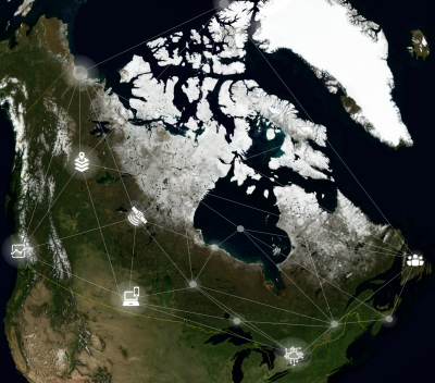
The project focused on conducting UNA and UCD for targeted Canadian stakeholders, the international Arctic community, and Indigenous peoples/communities/organizations across Canada and internationally. The objective of the project is to conceptualize, document, frame and develop detailed UNA and UCD studies in terms of data and services, standards, technologies, operational policies, Indigenous roles and relationships, and collaboration, leadership and governance.

Services Provided

Hatfield worked with Natural Resources Canada (NRCan) to conduct a UNA to research and detail spatial data infrastructure (SDI) requirements of different communities: Canadian stakeholders (CGDI) and International Arctic community and Indigenous communities (First Nations, Inuit, Métis). The resulting UNA provided a 2017-2018 landscape of existing users and new users of the CGDI. The project results helped NRCan understand the key needs for the evolution of the CGDI and Arctic SDI. Furthermore, the results will help guide the development, maintenance, evolution and awareness of both SDIs.

User Needs Assessment and User Engagement Materials for the Canadian Geospatial Data Infrastructure

August 6, 2020 by

Find out more about our services from our team of technical experts

Connect With Us
  • Home
  • About
  • Projects
  • News
  • Careers
  • Contact
  • Agent Orange

Sectors

  • Marine
  • Forestry
  • Infrastructure
  • International Development
  • Mining & Exploration
  • Oil & Gas
  • Pulp & Paper
  • Clean Energy

Services

  • WATER
  • Fish & Fish Habitat
  • Effects Monitoring & Ecotoxicology
  • Hydrology
  • Hydrogeology
  • Marine Ecology
  • Marine & Coastal Infrastructure
  • Regulatory Permitting
  • LAND
  • Infrastructure Development
  • Vegetation & Wetlands
  • Forestry
  • Wildlife
  • Regulatory Permitting
  • PEOPLE
  • Social Science
  • Engagement & Consultation
  • Knowledge Management
  • Human Centered Design
  • TECHNOLOGY
  • GIS & Mapping
  • Remote Sensing
  • Data & Information Management
  • Data Analytics
Copyright © 2021 Hatfield Consultants
  • Terms & Conditions
  • Privacy Policy
  • About
    ▼
    • At A Glance
    • Our Leaders
    • Our History
    • Corporate Social Responsibility
    • Quality Management
    • Health & Safety
    • Environmental Policy
    • Indigenous Relations
    • Regions
      ▼
      • Canada
      • Indonesia
      • Africa
  • Services
    ▼
    • Water
      ▼
      • Fish & Fish Habitat
      • Effects Monitoring & Ecotoxicology
      • Hydrology
      • Hydrogeology
      • Marine Ecology
      • Marine & Coastal Infrastructure
      • Regulatory Permitting
    • Land
      ▼
      • Infrastructure Development
      • Vegetation & Wetlands
      • Forestry
      • Wildlife
      • Regulatory Permitting
    • People
      ▼
      • Social Science
      • Engagement & Consultation
      • Knowledge Management
      • Human Centered Design
    • Technology
      ▼
      • GIS & Mapping
      • Remote Sensing
      • Data & Information Management
      • Data Analytics
  • Sectors
    ▼
    • Marine
    • Forestry
    • Infrastructure
    • International Development
    • Mining & Exploration
    • Oil & Gas
    • Pulp & Paper
    • Clean Energy
  • Projects
  • News
  • Careers
    ▼
    • Why Work at Hatfield?
    • Current Opportunities
  • Contact