Hatfield Consultants

  • About
    • At A Glance
    • Our Leaders
    • Our History
    • Corporate Social Responsibility
    • Quality Management
    • Health & Safety
    • Environmental Policy
    • Indigenous Relations
    • Regions
      • Canada
      • Indonesia
      • Africa
  • Services
    • Water
      • Fish & Fish Habitat
      • Effects Monitoring & Ecotoxicology
      • Hydrology
      • Hydrogeology
      • Marine Ecology
      • Marine & Coastal Infrastructure
      • Regulatory Permitting
    • Land
      • Infrastructure Development
      • Vegetation & Wetlands
      • Forestry
      • Wildlife
      • Regulatory Permitting
    • People
      • Social Science
      • Engagement & Consultation
      • Knowledge Management
      • Human Centered Design
    • Technology
      • GIS & Mapping
      • Remote Sensing
      • Data & Information Management
      • Data Analytics
  • Sectors
    • Marine
    • Forestry
    • Infrastructure
    • International Development
    • Mining & Exploration
    • Oil & Gas
    • Pulp & Paper
    • Clean Energy
  • Projects
  • News
  • Careers
    • Why Work at Hatfield?
    • Current Opportunities
  • Contact

Nicomekl-Serpentine Watershed Updated Aquifer Mapping and Water Balance

You are here: Home / Projects / Nicomekl-Serpentine Watershed Updated Aquifer Mapping and Water Balance

Nicomekl-Serpentine Watershed Updated Aquifer Mapping and Water Balance

Client

BC Ministry of Forests

Location

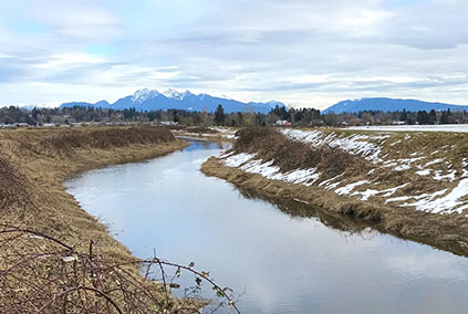
Surrey, British Columbia

Project Duration

2019 – 2020

Background

Since 1996, no surface water licenses have been issued in the Nicomekl and Serpentine watersheds due to concerns of potential impacts from additional water diversions on the salmon populations in the rivers. With the implementation of the Water Sustainability Act (WSA) in 2016, all existing and new non-domestic groundwater users are required to apply for a water licence. The WSA requires that decisions on all water licenses for new diversions (including currently unauthorized surface water diversions) must consider environmental flow needs (EFN). For groundwater users, EFN must be considered for new water licences where it is reasonably likely that the source aquifer is hydraulically connected to a stream and may be considered for existing use groundwater.

Services Provided

Hatfield’s work included updated aquifer mapping and monthly water balances for the Nicomekl and Serpentine watersheds, as well as a preliminary EFN assessment. Together these studies are initial steps in a process roadmap, intended to lead to sustainable water allocation in the Nicomekl and Serpentine watersheds. The Hatfield studies concluded that there should be no further surface water allocation, potentially except for wet season withdrawals with storage use during low flow times of the year. Potential for additional groundwater use in the study area may exist for those aquifers with low to moderate current groundwater use and low to moderate potential to impact streamflows. Advantages of promoting groundwater use over surface water diversions would include less direct impacts on streamflows and mitigation of seasonality of these impacts. However, numerical groundwater flow modelling should be done to better inform sustainable yield assessments and allocation (licensing) decisions.

Nicomekl-Serpentine Watershed Updated Aquifer Mapping and Water Balance

September 8, 2022 by

Find out more about our services from our team of technical experts

Connect With Us
  • Home
  • About
  • Projects
  • News
  • Careers
  • Contact
  • Agent Orange

Sectors

  • Marine
  • Forestry
  • Infrastructure
  • International Development
  • Mining & Exploration
  • Oil & Gas
  • Pulp & Paper
  • Clean Energy

Services

  • WATER
  • Fish & Fish Habitat
  • Effects Monitoring & Ecotoxicology
  • Hydrology
  • Hydrogeology
  • Marine Ecology
  • Marine & Coastal Infrastructure
  • Regulatory Permitting
  • LAND
  • Infrastructure Development
  • Vegetation & Wetlands
  • Forestry
  • Wildlife
  • Regulatory Permitting
  • PEOPLE
  • Social Science
  • Engagement & Consultation
  • Knowledge Management
  • Human Centered Design
  • TECHNOLOGY
  • GIS & Mapping
  • Remote Sensing
  • Data & Information Management
  • Data Analytics
Copyright © 2021 Hatfield Consultants
  • Terms & Conditions
  • Privacy Policy
  • About
    ▼
    • At A Glance
    • Our Leaders
    • Our History
    • Corporate Social Responsibility
    • Quality Management
    • Health & Safety
    • Environmental Policy
    • Indigenous Relations
    • Regions
      ▼
      • Canada
      • Indonesia
      • Africa
  • Services
    ▼
    • Water
      ▼
      • Fish & Fish Habitat
      • Effects Monitoring & Ecotoxicology
      • Hydrology
      • Hydrogeology
      • Marine Ecology
      • Marine & Coastal Infrastructure
      • Regulatory Permitting
    • Land
      ▼
      • Infrastructure Development
      • Vegetation & Wetlands
      • Forestry
      • Wildlife
      • Regulatory Permitting
    • People
      ▼
      • Social Science
      • Engagement & Consultation
      • Knowledge Management
      • Human Centered Design
    • Technology
      ▼
      • GIS & Mapping
      • Remote Sensing
      • Data & Information Management
      • Data Analytics
  • Sectors
    ▼
    • Marine
    • Forestry
    • Infrastructure
    • International Development
    • Mining & Exploration
    • Oil & Gas
    • Pulp & Paper
    • Clean Energy
  • Projects
  • News
  • Careers
    ▼
    • Why Work at Hatfield?
    • Current Opportunities
  • Contact