Hatfield Consultants

  • About
    • At A Glance
    • Our Leaders
    • Our History
    • Corporate Social Responsibility
    • Quality Management
    • Health & Safety
    • Environmental Policy
    • Indigenous Relations
    • Regions
      • Canada
      • Indonesia
      • Africa
  • Services
    • Water
      • Fish & Fish Habitat
      • Effects Monitoring & Ecotoxicology
      • Hydrology
      • Hydrogeology
      • Marine Ecology
      • Marine & Coastal Infrastructure
      • Regulatory Permitting
    • Land
      • Infrastructure Development
      • Vegetation & Wetlands
      • Forestry
      • Wildlife
      • Regulatory Permitting
    • People
      • Social Science
      • Engagement & Consultation
      • Knowledge Management
      • Human Centered Design
    • Technology
      • GIS & Mapping
      • Remote Sensing
      • Data & Information Management
      • Data Analytics
  • Sectors
    • Marine
    • Forestry
    • Infrastructure
    • International Development
    • Mining & Exploration
    • Oil & Gas
    • Pulp & Paper
    • Clean Energy
  • Projects
  • News
  • Careers
    • Why Work at Hatfield?
    • Current Opportunities
  • Contact

Earth Observation for Rapid Burned Area Mapping (R-BAM)

You are here: Home / Projects / Earth Observation for Rapid Burned Area Mapping (R-BAM)

Earth Observation for Rapid Burned Area Mapping (R-BAM)

Client

Canadian Space Agency (CSA)

Location

Canada (various locations)

Project Duration

November 2016 – November 2018

Background

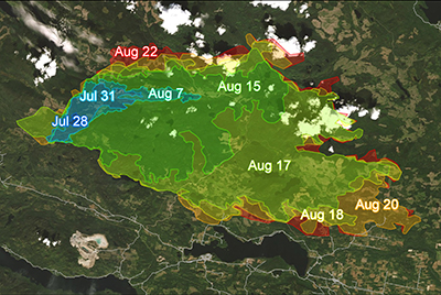
With wildfire frequency and intensity increasing across many parts of the world, government agencies, private companies, and First Nations require timely and accurate information to assess wildfire burn areas and progression. The Rapid Burned Area Mapping (R-BAM) technology was required to complement conventional wildfire observation and assessment techniques in support of wildfire response and recovery efforts.

Services Provided

Hatfield developed R-BAM tools to provide new methods to combine optical/thermal and radar satellite Earth observation (EO) data with machine learning analytics.

R-BAM Optical Services and Tools provide automated workflows that process multispectral EO time series data in order to create cloud-free composite images to assess burn severity through change detection analysis as a wildfire progresses. The advanced R-BAM algorithms incorporate Sentinel-2 and Landsat 8 imagery to create maps and geospatial data that support wildfire response and recovery.

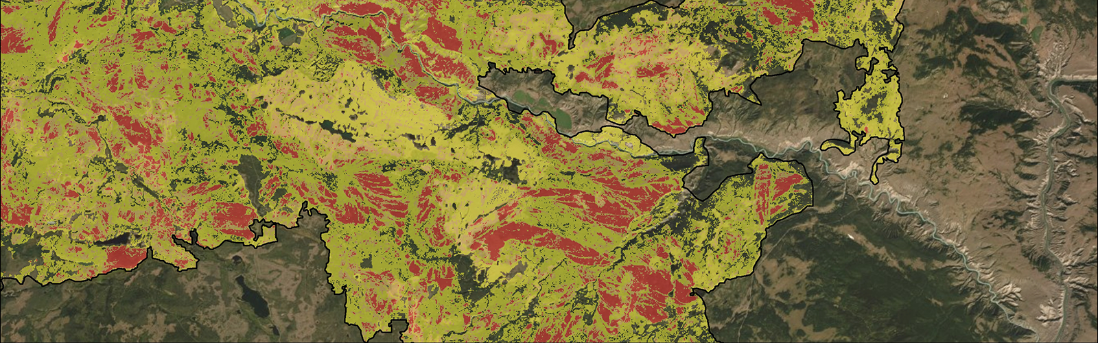
R-BAM Radar Services and Tools were developed because radar data have the capability to operate in the presence of clouds, haze, and smoke. Radar is sensitive to the change in the structural characteristics of a forest when a wildfire occurs, which can be used to map burned areas. Hatfield assessed the potential for radar data to contribute to wildfire progression monitoring, including factors that may affect the reliability of information extraction from radar, such as forest type, topography, and moisture conditions.

Earth Observation for Rapid Burned Area Mapping (R-BAM)

June 11, 2020 by

Find out more about our services from our team of technical experts

Connect With Us
  • Home
  • About
  • Projects
  • News
  • Careers
  • Contact
  • Agent Orange

Sectors

  • Marine
  • Forestry
  • Infrastructure
  • International Development
  • Mining & Exploration
  • Oil & Gas
  • Pulp & Paper
  • Clean Energy

Services

  • WATER
  • Fish & Fish Habitat
  • Effects Monitoring & Ecotoxicology
  • Hydrology
  • Hydrogeology
  • Marine Ecology
  • Marine & Coastal Infrastructure
  • Regulatory Permitting
  • LAND
  • Infrastructure Development
  • Vegetation & Wetlands
  • Forestry
  • Wildlife
  • Regulatory Permitting
  • PEOPLE
  • Social Science
  • Engagement & Consultation
  • Knowledge Management
  • Human Centered Design
  • TECHNOLOGY
  • GIS & Mapping
  • Remote Sensing
  • Data & Information Management
  • Data Analytics
Copyright © 2021 Hatfield Consultants
  • Terms & Conditions
  • Privacy Policy
  • About
    ▼
    • At A Glance
    • Our Leaders
    • Our History
    • Corporate Social Responsibility
    • Quality Management
    • Health & Safety
    • Environmental Policy
    • Indigenous Relations
    • Regions
      ▼
      • Canada
      • Indonesia
      • Africa
  • Services
    ▼
    • Water
      ▼
      • Fish & Fish Habitat
      • Effects Monitoring & Ecotoxicology
      • Hydrology
      • Hydrogeology
      • Marine Ecology
      • Marine & Coastal Infrastructure
      • Regulatory Permitting
    • Land
      ▼
      • Infrastructure Development
      • Vegetation & Wetlands
      • Forestry
      • Wildlife
      • Regulatory Permitting
    • People
      ▼
      • Social Science
      • Engagement & Consultation
      • Knowledge Management
      • Human Centered Design
    • Technology
      ▼
      • GIS & Mapping
      • Remote Sensing
      • Data & Information Management
      • Data Analytics
  • Sectors
    ▼
    • Marine
    • Forestry
    • Infrastructure
    • International Development
    • Mining & Exploration
    • Oil & Gas
    • Pulp & Paper
    • Clean Energy
  • Projects
  • News
  • Careers
    ▼
    • Why Work at Hatfield?
    • Current Opportunities
  • Contact