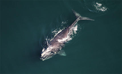
Hatfield to support endangered right whale protection through new space-based detection system using deep learning applied to satellite images.
Jan 28, 2021
Hatfield is thrilled to announce their involvement with the Canadian Space Agency (CSA) for the development of smartWhales solutions to support the protection of North Atlantic right whales (NARWs). With overall funding of $5.3-million from the federal government, and in collaboration with Fisheries and Oceans Canada (DFO) and Transport Canada (TC), smartWhales will utilize satellite data to help detect and monitor the presence of the NARWs in Canadian waters in near-real time, while predicting their movements and monitoring their safety.
Following the devastating increase in NARW mortalities over recent years, from collisions with vessels and entanglement in fishing gear, innovative solutions to better protect and track the whales are needed. The CSA has enlisted five consortia to develop smartWhales solutions using space-based technologies.
Hatfield is to lead a multi-disciplinary consortium of industry scientists, academia, and non-government organizations to develop a platform that will detect and monitor NARWs using deep learning models, high-resolution space-based satellite imagery, automation, and geoscience computing. Hosted in a cloud platform, smartWhales will be a major improvement to existing methods and systems, while ultimately facilitating the goal of NARW conservation for our planet. Hatfield’s consortium comprises:
- Kim Davies – Assistant Professor in Biological Sciences at University of New Brunswick, St John; Adjunct Professor, Oceanography, Dalhousie University. Scientific advisor for the Slocum glider program of the Coastal Environmental Observation Technology and Research (CEOTR) group at Dalhousie University.
- David Johnston – Director of the Marine Robotics and Remote Sensing (MaRRS) Lab, Duke University. Leading researcher in advancing marine science and conservation applications with new technology, including morphometrics of marine mammals using photogrammetric techniques and artificial intelligence (AI).
- Sean Brilliant, Canadian Wildlife Federation (CWF) – Manager of Marine Programs leading NARW research projects focused on fishing gear entanglement prevention and impact of vessel strikes, including development of models to predict when and where they might be at risk.
- AltaML – a leading Canadian technology company developing machine learning and AI solutions in collaboration with domain experts.
A smartWhales consortium led by Arctus, an R&D company specialized in optical remote sensing of aquatic environments, will address the challenges of modeling oceanographic, meteorological, and NARW habitat. Hatfield is a member of the consortium supporting the development of a cloud-computing modeling environment using our GEO Analytics Canada platform.
Hatfield has a long history of developing space-based technology to improve environmental assessment and monitoring, specifically in coastal environments. Extensive experience in remote sensing, big data science and analytics, and marine biology and conservation, makes Hatfield a valuable partner in this smartWhales initiative, and we look forward to collaborating with all experts involved for the conservation of this endangered whale species.
Dr. Andy Dean, Senior Partner at Hatfield, commented that “Hatfield is looking forward to leading an amazing team of scientists to use technology and deep learning to support North Atlantic right whale conservation, while collaborating with all the smartWhales consortia and Federal scientists.”
For more information on this initiative, read the full announcement on the Canadian Space Agency’s website, or view our coverage on CTV National News or Global News.